Whether starting from scratch, or renovating, it is important that you take the time to plan your design before you start to plant.
The first step towards realizing your Xeriscape landscape is to develop a plan. This can be achieved by first contemplating and deciding on your needs and then listing your ideas on paper. What do you want from your landscape in terms of outdoor activities, gardening interests, and functional concerns such as pathways, shade, and service areas.
Assess and include these characteristics of your site to your list: Topography, orientation to the sun, existing vegetation, views both good and bad, desirable views, prevailing winds and microclimates provided by buildings or shade etc.
Create different water use zones and allocate the water where it will most directly contribute to the beauty and comfort of your home.
Decide on the type or style that suits your house and neighborhood. Consider options to provide areas for activities, services and storage. Take advantage of views including those from the house. Provide for screening and privacy.
Provide outdoor seating areas with sun and shade. Provide the pathways. Work out a strategy for grading and drainage. Plan to channel runoff from your house, outbuildings and paved surfaces to supplement the water elsewhere, for example, to an existing shade tree.
Planning and Design: Start by making a Base Map & Property Analysis
Whether or not the initial planning process is done on paper, it is a good idea to record your finished plan, for reference, since it is often necessary to schedule the work over an extended period of time. Also having your plan outlined on paper makes it much easier to tackle the next step: Design.
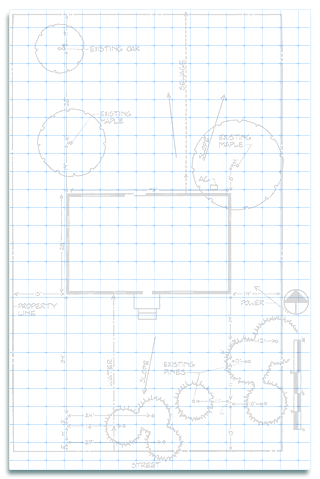
1: Base Map. With a piece of graph paper draw to scale the location of the house, its orientation to the sun, and other structures on the site. Note the orientation of the home (i.e. north, south, east or west)
2: Property Analysis. Next, with a piece of tracing paper over the base map use arrows to indicate the direction of desirable views you want to emphasize and undesirable views you want to screen. Indicate wind direction and possible street noise. Label this sheet site analysis of property.


Incorporate shade into the design. Shade reduces water loss and keeps the landscape 20% cooler than in full sun. Effective shade management involves using shade to block sunlight from striking the soil surface, to intercept, scatter and reflect radiant energy. Structures like trellises, arbors, walls or fences can provide shade.
The objective here will be to work out a strategy that will be influenced by water-use zones. This concept is founded on the idea of water conservation and savings to your budget. Over all you are going to reduce water consumption, as compared to the traditional landscape, but the savings will not be uniformly applied.

Think of an oasis. You will need to establish the core area in your design where water use is highest. This could be a lawn, or various outdoor areas surrounded by lush plantings. Usually these high maintenance areas are established close to the house for convenience, for visibility from the house, and for the cooling benefits they present to the house during the summer.
Extending out from this mini-oasis there is a transitional zone that relies on plants with moderate water demand. And extending further is the driest zone. In this zone you will use native and similar plants adapted to our arid climate which demand very low water use. For greatest water conservation, design as much of your landscape as possible into low water-use zones.
3: Plan for different use areas. Overlay the base map and the site analysis sheet with another piece of tracing paper. Personalize your landscape to meet your needs and uses by indicating the public, private and service areas of your landscape. Circle the children’s play area, private patio or cook area. Indicate a flower or vegetable garden. Indicate the services areas, trash cans, outdoor equipment, AC units or the dog house. Consider how these areas will be developed based on space requirements for each activity.
4: Establish water-use zones. In addition to dividing the landscape into use areas, a Xeriscape plan further divides the landscape by planning areas by their water-use. With another piece of tracing paper, divide the areas into three water use zones: high (regular watering), moderate (occasional watering) and low (little to no watering). An individual landscape may include several of these zones.
5: Develop a master plan after you have settled on a design scheme and a water management arrangement. This is a plan showing the final product of your efforts thus far. Identify planting spaces as well as edging materials, groundcovers and paving. Use straight lines or smooth flowing curves… unnecessary bends can be maintenance problems. Simplicity in design is often the best choice.
6: Fit Plants areas to the Plan. As you achieve the style and overall design effects you desire, select plant shapes and groupings that complement and accent the good features of the architecture and construction materials rather than overpower them. Group plantings to conform to the shape of plant beds. Avoid rigid formal, geometric plantings as much as possible. We will address more detailed plant arrangement schemes in the sections to follow.
As your master plan materializes, you may feel anxious to start identifying your plant selections, but first you need to know a few things about your soil.
